Free
$200/month *
A powerful GIS platform, designed for small teams.
* billed annually
Felt is discounted for non-profits and free for education
| Free | Team | Enterprise | |
|---|---|---|---|
| Sharing & Collaboration | |||
| Share via URL | ✔️ | ✔️ | ✔️ |
| Invite collaborators | ✔️ | ✔️ | ✔️ |
| Real-time collaboration | ✔️ | ✔️ | ✔️ |
| Library of 100+ data sources | ✔️ | ✔️ | ✔️ |
| Project-level permissions | ✔️ | ✔️ | ✔️ |
| Workspace-level permissions | ❌ | ❌ | ✔️ |
| Set default map permissions | ❌ | ❌ | ✔️ |
| Custom team library | ❌ | ❌ | ✔️ |
| Map Creation & Editing | |||
| Create points, lines, polygons | ✔️ | ✔️ | ✔️ |
| Edit geometry attributes | ✔️ | ✔️ | ✔️ |
| Add annotations (notes, photos, etc) | ✔️ | ✔️ | ✔️ |
| Standard, light, & dark basemaps | ✔️ | ✔️ | ✔️ |
| Satellite basemaps | ✔️ | ✔️ | ✔️ |
| Custom basemaps | ❌ | ✔️ | ✔️ |
| Export to image, PDF | ❌ | ✔️ | ✔️ |
| Export to GeoJSON, GeoPackage, & GeoTIFF | ❌ | ✔️ | ✔️ |
| Upload Anything | |||
| Vector (.shp, .gpkg, .geojson, .kml, etc) | ❌ | ✔️ | ✔️ |
| Raster Data (.tiff, .asc, etc) | ❌ | ✔️ | ✔️ |
| Spreadsheets (.csv, .xls, .numbers, .etc) | ❌ | ✔️ | ✔️ |
| OGC Web Services (WMTS, WMS, etc) | ❌ | ✔️ | ✔️ |
| Google Sheets | ❌ | ✔️ | ✔️ |
| Geomatching | ❌ | ✔️ | ✔️ |
| Geocoding | ❌ | ✔️ | ✔️ |
| Postgres / PostGIS | ❌ | ❌ | ✔️ |
| Snowflake | ❌ | ❌ | ✔️ |
| BigQuery | ❌ | ❌ | ✔️ |
| Redshift | ❌ | ❌ | ✔️ |
| S3 | ❌ | ❌ | ✔️ |
| STAC | ❌ | ❌ | ✔️ |
| Microsoft SQL Server | ❌ | ❌ | ✔️ |
| ESRI FeatureServers, MapServers, ImageServers | ❌ | ❌ | ✔️ |
| Advanced GIS | |||
| Numeric visualizations | ❌ | ✔️ | ✔️ |
| Categorical visualizations | ❌ | ✔️ | ✔️ |
| Heatmaps | ❌ | ✔️ | ✔️ |
| Attribute table | ❌ | ✔️ | ✔️ |
| Raster Styling | ❌ | ✔️ | ✔️ |
| Data search | ❌ | ✔️ | ✔️ |
| Data filters | ❌ | ✔️ | ✔️ |
| Popup styling | ❌ | ✔️ | ✔️ |
| Spatial transformations | ❌ | ✔️ | ✔️ |
| Raster calculations | ❌ | ❌ | ✔️ |
| QGIS integration | ❌ | ❌ | ✔️ |
| Python notebook integration | ❌ | ❌ | ✔️ |
| H3 visualization | ❌ | ❌ | ✔️ |
| Live refreshing layers | ❌ | ❌ | ✔️ |
| PowerBI integration | ❌ | ❌ | ✔️ |
| Notion integration | ❌ | ❌ | ✔️ |
| Custom Apps & Dashboards | |||
| Mobile Experience | |||
| QGIS integration | ✔️ | ✔️ | ✔️ |
| Embedded maps | ❌ | ✔️ | ✔️ |
| White-labeled maps | ❌ | ❌ | ✔️ |
| REST API | ❌ | ❌ | ✔️ |
| JavaScript SDK | ❌ | ❌ | ✔️ |
| Custom interactions (custom HTML, iframes) | ❌ | ❌ | ✔️ |
| Components (statistics, time series, histogram, etc) | ❌ | ❌ | ✔️ |
| Time sliders | ❌ | ❌ | ✔️ |
| Viewer tools (measure, export, tables) | ❌ | ❌ | ✔️ |
| Custom Apps & Dashboards | |||
| AI for Javascript Extensions | ❌ | ❌ | ✔️ |
| AI for SQL Queries | ❌ | ❌ | ✔️ |
| AI for Custom Popups | ❌ | ❌ | ✔️ |
| ❌ | ❌ | ||
| Usage | |||
| Map views | 5,000 / mo | 10,000 / mo | Up to 10M / mo |
| Data hosting | – | 25 GB | Up to 5 TB |
| Data processing | – | 5 GB / mo | Up to 1 TB / mo |
| Members | 25 | 25 | Up to 1,000 |
| Editors | 3 | 3 | Up to 200 |
| Security | |||
| SOC2 compliance | ✔️ | ✔️ | ✔️ |
| GDPR compliance | ✔️ | ✔️ | ✔️ |
| Transfer member content | ❌ | ❌ | ✔️ |
| Domain capture | ❌ | ❌ | ✔️ |
| Single sign-on & SAML (SSO) | ❌ | ❌ | ✔️ |
| Regional Hosting | ❌ | ❌ | ✔️ |
| Private cloud or VPC deployment | ❌ | ❌ | ✔️ |
| Support | |||
| Help center | ✔️ | ✔️ | ✔️ |
| Video tutorials | ✔️ | ✔️ | ✔️ |
| Email support | ❌ | ✔️ | ✔️ |
| Dedicated Customer Success | ❌ | ❌ | ✔️ |
| Technical Support | ❌ | ❌ | ✔️ |
| Hands-on training | ❌ | ❌ | ✔️ |
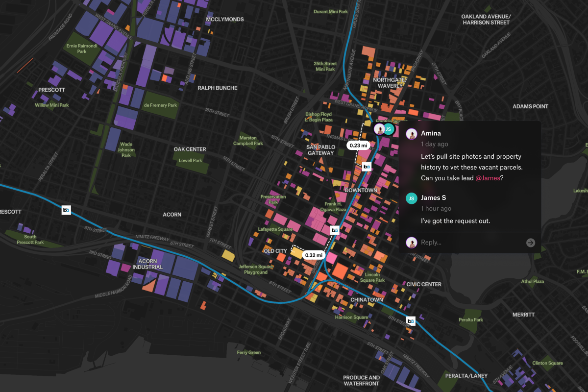
Design rich popups, sidebars, and modals that deliver key insights instantly, giving map developers and app builders complete control over user experience in GIS app development.
Design rich popups, sidebars, and modals that deliver key insights instantly, giving map developers and app builders complete control over user experience in GIS app development.
Design rich popups, sidebars, and modals that deliver key insights instantly, giving map developers and app builders complete control over user experience in GIS app development.
Design rich popups, sidebars, and modals that deliver key insights instantly, giving map developers and app builders complete control over user experience in GIS app development.
Design rich popups, sidebars, and modals that deliver key insights instantly, giving map developers and app builders complete control over user experience in GIS app development.